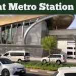
Dubai Metro Map: The Dubai Metro 🚅 is the backbone and one of the most efficient and trendy public transportation systems in the world, serving millions of passengers annually with fast, reliable, and eco-friendly travel.

The architecture of the Dubai map is designed by the international architectural company Aedas. The transport system is operated under the leadership of the Roads and Transport Authority (RTA). According to the RTA declaration, almost 143.9 million people used the Dubai Metro in the first half of 2025.
The metro operates under two lines, Red and Green. It continues to evolve, delivering the most reliable connectivity, convenience, and sustainability. In this article, I have outlined a comprehensive guide to the Dubai Metro’s route, stations, and times.
You may Like: Dubai Metro Timings 2026: A Complete GuideQuick Highlights
| Feature | Details |
|---|---|
| Total Network Length | 89.6 kilometers (55.7 miles) |
| Total Stations | 55 stations (Red: 35, Green: 20) |
| Metro Lines | 2 operational (Red & Green), 1 under construction (Blue) |
| System Type | Fully automated, driverless |
| World Record | World’s longest driverless metro (regained 2021) |
| Daily Ridership | ~800,000+ passengers per day |
| Annual Ridership (2024) | 275.4 million passengers |
| First Half 2025 | 143.9 million passengers |
| Operating Authority | Roads and Transport Authority (RTA) |
| Operator | Keolis MHI Consortium (since Sep 2021) |
| Operational Since | September 9, 2009 |
| Fare Zones | 7 zones (Metro uses Zones 1, 2, 5, 6) |
| Interchange Stations | 2 major (Union & BurJuman) |
| Tram Connections | 2 stations (DMCC & Sobha Realty) |
| Maximum Speed | 110 km/h (68 mph) |
| Minimum Fare | AED 3 (single zone) |
| Payment Methods | Nol Cards (Silver, Gold, Blue, Red Ticket) |
| Accessibility | 100% wheelchair accessible |
| WiFi Availability | Free WiFi at all stations and trains |
| CCTV Coverage | 3,000+ cameras across network |
| Mobile Coverage | Complete network coverage |
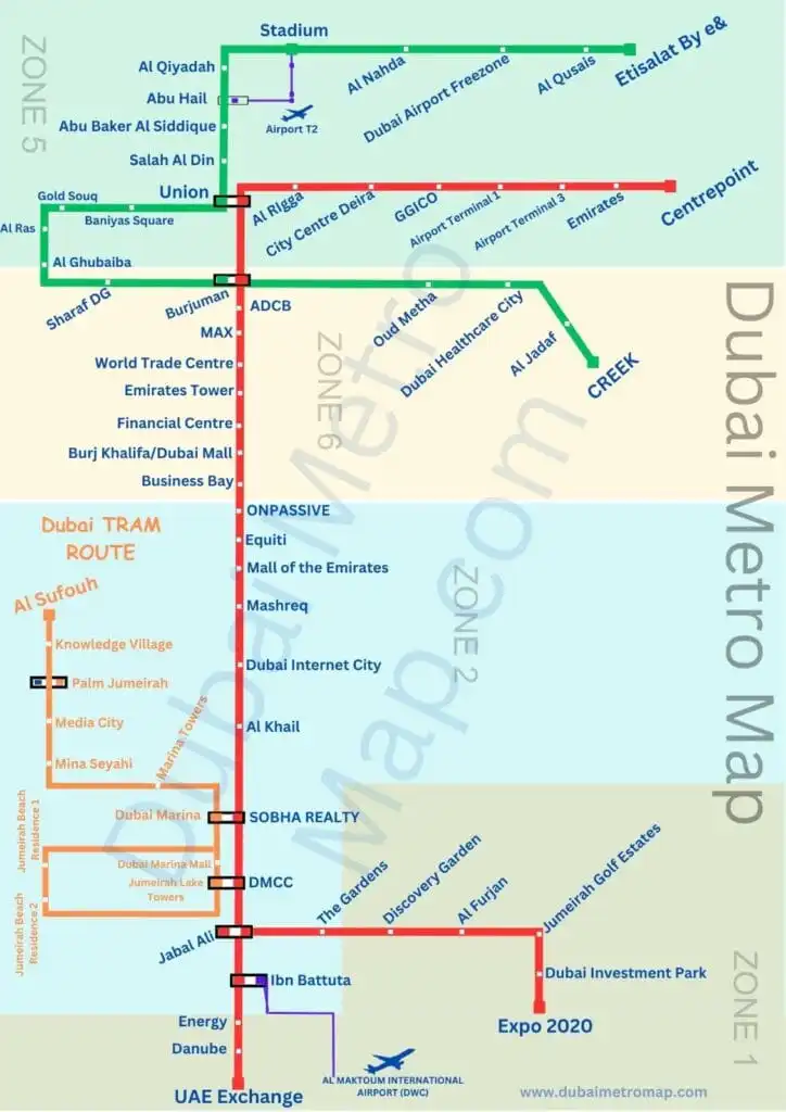
The Dubai Metro Map illustrates the metro lines on the City map. The Red and Green lines indicate the fast, traffic-free service provided by the trains.
Future Dubai Metro Stations 2030: Map
Dubai Metro Map PDF Download
Dubai Metro Red and Green Line Map 2026
Red Line Map

Green Line Map
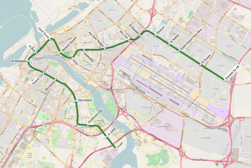
As shown in the picture above, the lines of the line work separately. Two Red Line Stations interchange with two Green Line Stations; two other Red Line Stations interchange with tram lines. The list is included below:
- The Red Line R18 and Green Line G20 interchange at Union.
- Red Line R19 and Green Line G26 interchange at BurJuman.
- The Red Line R38 interchanges with the Branch Line at Jabal Ali.
- The Red Line R36 interchanges with the Tram Line at SHOBHA Realty.
- The Red Line R37 interchanges with the Tram Line at DMCC.
Dubai Metro Guide – Video
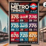
Timings and Frequency
| Day | Operating Hours | Frequency |
|---|---|---|
| Weekdays | 5:00 AM–1:15 AM | Every 4-7 minutes |
| Weekends | 5:00 AM–2:15 AM | Every 3-5 minutes |
| Fridays | 8:00 AM–1:15 AM | Every 5-10 minutes |
Dubai Metro Operating Hours in Spring
| Day | Timings |
|---|---|
| Monday to Thursday | 5 am to 12 am (midnight) |
| Friday | 5 am to 1 am (next day) |
| Saturday | 5 am to 12 am (midnight) |
| Sunday | 8 am to 12 am (midnight) |
Tram Line Timing
| Monday to Saturday | 6:00 AM to 1:00 AM (Next Day) |
| Sunday | 9:00 AM to 1:00 AM (Next Day) |
Dubai Metro Fares Zones
The Dubai Metro fares are designed in a fixed-tier system that includes 4 parts:
| Zone | Coverage Area | Key Stations |
|---|---|---|
| Zone 1 | Dubai Marina, JBR, JLT | DMCC, Sobha Realty, Ibn Battuta |
| Zone 2 | Expo 2020, Dubai South | Expo 2020, Energy, UAE Exchange |
| Zone 5 | Deira, Al Qusais | Etisalat, Al Qusais, Stadium, Al Nahda |
| Zone 6 | Bur Dubai, City Centre | Union, BurJuman, Business Bay, Mall of Emirates |
Fares for each tier might be separate from time to time. The disabled have no fares, and a special discount exists for seniors and students.
Dubai traffic is often divided into seven zones; apart from this, three more are not included in the metro area. Metro stations are categorized into zones 1, 2, 5, and 6. Other traffic zones included in the Dubai public transport zones included buses. Extra charges applied to buses after metro rides.
Ticketing System
The Dubai Metro ticket prices are as follows:
Dubai Metro Ticket Price & NOL Card
| Ticket Type | Usage | 1 Zone | 2 Zones (<3 km) | 2 Zones | 3+ Zones |
|---|---|---|---|---|---|
| Standard Adult Ticket (Red) | Temporary, single rides. | 4 AED | 4 AED | 6 AED | 8.50 AED |
| Pre-paid Standard Adult Ticket (Silver NOL) | Standard, rechargeable. | 3 AED | 3 AED | 5 AED | 7.50 AED |
| Blue NOL Card | Personalized NOL cards. | 1.50 AED | 1.50 AED | 2.50 AED | 3.75 AED |
| Gold Class Red Ticket | Access to premium cabins. | 8 AED | 8 AED | 12 AED | 17 AED |
| Gold Class Pre-Paid | – | 6 AED | 6 AED | 10 AED | 15 AED |
To buy the tickets, first, you must have a Nol Card, issued by the Road and Transport Authority (RTA). The card is considered a smart card, like an ATM card, which is easily available on the RTA through the RTA Dubai website at www.rta.ae.
Dubai Metro Routes
Key Metro Stations
- Union Station: The largest interchange between the Red and Green Lines.
- Burj Khalifa/Dubai Mall Station: Acts as the gateway to the city’s most iconic attractions.
- Jebel Ali Station: A major node connecting industrial and residential areas.
Red Line Complete Overview
| Metric | Data |
|---|---|
| Total Length | 67.1 km (41.7 miles) |
| Number of Stations | 35 stations |
| Station Types | 24 elevated, 4 underground, 1 at-grade |
| Route | Centrepoint (Rashidiya) ↔ Expo 2020 |
| Branch Line | To Life Pharmacy (formerly UAE Exchange) |
| Zone Coverage | Zones 1, 2, 5, 6 |
| Complete Journey Time | ~90 minutes end-to-end |
| Train Frequency (Peak) | Every 3.75 minutes (16 trains/hour) |
| Train Frequency (Off-Peak) | Every 5-7 minutes (8.5 trains/hour) |
| Trainsets in Service | 44 trainsets |
| Key Attractions | Airport, Burj Khalifa, Dubai Mall, Marina, Expo City |
The Red Line is considered the longest and most proactive metro line, connecting pivotal zones like Rashidiya, Dubai International Airport, Downtown Dubai, and Jebel Ali. It acts as the main arterial route for daily commuters and visitors.
Dubai Metro Red Line Stations
| R11 – Centrepoint | R32 – Mall of the Emirates |
| R12 – Emirates | R33 – mashreq |
| R13 – Airport Terminal 3 | R34 – Dubai Internet City |
| R14 – Airport Terminal 1 | R35 – Al Khail |
| R15 – GGICO | R36 – Sobha Realty |
| R16 – City Centre Deira | R37 – DMCC |
| R17 – Al Rigga | R38 – Jabal Ali |
| R18 – Union | R39 – Ibn Battuta |
| R19 – Burjuman | R40 – Energy |
| R20 – ADCB | R41 – Danube |
| R21 – max | R42 – UAE Exchange |
| R22 – World Trade Centre | R70 – The Gardens |
| R23 – Emirates Towers | R71 – Discovery Gardens |
| R24 – Financial Centre | R72 – Al Furjan |
| R25 – Burj Khalifa / Dubai Mall | R73 – Jumeirah Golf Estates |
| R26 – Business Bay | R74 – Dubai Investment Park |
| R29 – ONPASSIVE | R76 – EXPO 2020 |
| R31 – Equiti | ————————————– |
Green Line Overview
| Metric | Data |
|---|---|
| Total Length | 22.5 km (14 miles) |
| Number of Stations | 20 stations |
| Station Types | 12 elevated, 8 underground |
| Route | Etisalat by e& ↔ Creek |
| Zone Coverage | Zones 5 and 6 |
| Complete Journey Time | ~40 minutes end-to-end |
| Train Frequency | Every 3.75-10 minutes |
| Trainsets in Service | 25 trainsets |
| Key Areas Served | Deira, Bur Dubai, Al Qusais, Dubai Creek |
| Heritage Sites | Gold Souk, Spice Souk, Al Fahidi, Dubai Museum |
The Green Line concentrates on connecting ancient parts of Dubai, such as Deira and Bur Dubai, with newer business junctions. The key stops include Union, Al Ghubaiba, and Dubai Healthcare City.
Dubai Metro Green Line Stations
| G11 – Etisalat by e& | G21 – Baniyas Square |
| G12 – Al Qusais | G22 – Gold Souq |
| G13 – Dubai Airport Free Zone | G23 – Al Ras |
| G14 – Al Nahda | G24 – Al Gubaiba |
| G15 – Stadium | G25 – Sharaf DG |
| G16 – Al Qiyadah | G26 – Burjuman |
| G17 – Abu Hail | G27 – Oud Metha |
| G18 – Abu Baker Al Siddique | G28 – Dubai Healthcare City |
| G19 – Salah Al Din | G29 – Al Jadaf |
| G20 – Union | G30 – Creek |
Blue Line – Future Expansion (2029)
| Metric | Data |
|---|---|
| Status | Under Construction (Started 2024) |
| Expected Opening | September 9, 2029 (20th Metro Anniversary) |
| Total Length | 30 km (18.6 miles) |
| Number of Stations | 14 stations |
| Station Types | 9 elevated, 5 underground |
| Investment | AED 18 billion |
| Route | Centrepoint (Red Line) ↔ Creek (Green Line) |
| Key Feature | World’s tallest metro station (74 meters) at Dubai Creek Harbour |
| Areas to Serve | Academic City, Silicon Oasis, Mirdif, Festival City |
| Impact | Circular network connecting all three lines |
Opened for Expo 2020, Route 2020 connects Jebel Ali with Expo City Dubai, including stops such as Discovery Gardens and Al Furjan.
Future Lines
Plans for the Blue and Purple lines aim to connect Dubai International Airport with Al Maktoum International Airport, further expanding the metro network.
Dubai Metro Tram Line Stations
| 01 – Jumeirah Beach Residence 1 | 07 – Mina Seyahi |
| 02 – Jumeirah Beach Residence 2 | 08 – Media City |
| 03 – Jumeirah Lakes Towers | 09 – Palm Jumeirah |
| 04 – Dubai Marina Mall | 10 – Knowledge Village |
| 05 – Dubai Marina | 11 – Al Sufouh |
| 06 – Marina Towers | —————————— |
Interchange and Connection Points
| Station Name | Lines Connected | Zone | Additional Connections |
|---|---|---|---|
| Union | Red (R18) + Green (G20) | Zone 6 | Bus Terminal, Gold Souk access |
| BurJuman | Red (R19) + Green (G26) | Zone 6 | BurJuman Mall, Bus connections |
| Sobha Realty | Red (R36) + Tram | Zone 1 | Dubai Marina Tram connection |
| DMCC | Red (R37) + Tram | Zone 1 | JLT Tram connection |
| Jabal Ali | Red (R38) + Branch Line | Zone 2 | – |
List of Renamed Dubai Metro Stations
Sometimes, the 🗺 map route has been changed after introducing new metro stations, after completing and announcing a new contract.
| Old Name | Updated Name |
|---|---|
| Rashidiya | Centrepoint |
| Sharaf DG | Mashreq |
| Al Jafiliya | Max |
| Al Karama | Abu Dhabi Commercial Bank (ADCB) |
| Al Fahidi | Sharaf DG |
| Nakheel Harbour and Tower | Jabal Ali |
| Noor Bank | Al Safa |
| Nakheel | Al Khail |
| Palm Deira | Gold Souq |
| Khalid Bin Al Waleed | BurJuman |
| DAMAC Properties | Marina, SHOBHA Realty |
| Jebel Ali | UAE Exchange |
| First Abu Dhabi Bank | Umm Al Sheif |
| Jumeirah Lakes Towers | Dubai Multi Commodities Centre (DMCC) |
Accessibility Features
Dubai Metro is organised to accommodate everyone:
- Wheelchair Ramps: Installed at all stations.
- Tactile Paths: For visually impaired passengers.
- Priority Seats: For elderly and differently-abled riders.
Top Tourist Routes Using the Map
| Itinerary | Route | Stations | Duration | Highlights |
|---|---|---|---|---|
| Old Dubai Heritage Trail | Green Line | Baniyas Square → Al Fahidi | 15 mins | Gold Souk, Spice Souk, Dubai Museum |
| Modern Dubai Icons | Red Line | Burj Khalifa/Dubai Mall → Mall of Emirates | 20 mins | Burj Khalifa, Dubai Mall, Souk Al Bahar |
| Beach & Marina Day | Red Line | Sobha Realty → DMCC + Tram | 35 mins | Dubai Marina, JBR Beach, The Walk |
| Airport to City Center | Red Line | Terminal 1/3 → Burj Khalifa | 25 mins | Direct airport connection |
| Complete Dubai Tour | Red + Green | Full network exploration | 2.5 hours | All major landmarks |
Sustainability Initiatives
Dubai Metro uses energy-efficient lighting, regenerative braking systems, and solar-powered features to reduce its carbon footprint.
FAQs
How can I get a Dubai Metro Map 2026?
Maps are obtainable at stations, online, and via the RTA app.
What happens if I lose my NOL card?
Report it to the RTA as soon as possible; the representative can block the card and transfer your balance to a new one.
Are pets allowed on the metro?
No, animals other than service animals are not allowed in the metro.
Is there an interactive Dubai Metro map online?
Yes, there are many interactive online maps for the Dubai Metro, which offer features such as route planning, live and offline maps. The official Roads and Transport Authority (RTA) website offers a comprehensive interactive journey planner.
Which metro line goes to Dubai Creek
The Green Line of the Dubai Metro goes to the Creek station (G30), nestled on the Bur Dubai side of the Dubai Creek.
How to find nearest metro station using map?
It’s not rocket science, you have to just go to Google and search ” station nearme”.
Conclusion
The Dubai Metro Map 2026 represents the city’s smart, sustainable urban evolution vision. The Dubai Metro provides a reliable and efficient service, whether you are a resident or a visitor, to explore the stunning and vibrant country of Dubai (United Arab Emirates), which is known as the dreamland for strangers.